The Cibola Project
A road-accessible, district-scale copper-gold porphyry target in central British Columbia, insufficiently tested at depth.
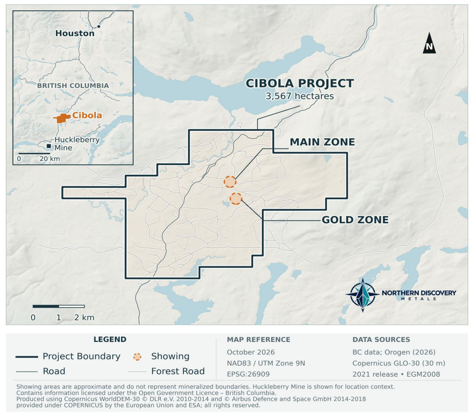
The Cibola Project is a road-accessible 3,567-hectare property 90 km south-southwest of Houston, British Columbia, in the centre of an emerging mining district. The haul road from the Huckleberry Mine crosses the property, and the claims are bounded to the west by Surge Copper's advanced Berg-Ootsa project.
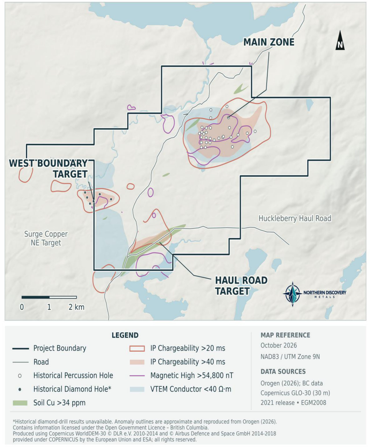
The Main Zone is defined by a historical IP chargeability anomaly approximately 3 × 1.7 km in extent, with overlapping electromagnetic and magnetic anomalies and mapped alteration that support a potential porphyry target. Drilling in the 1970s consisted of short percussion holes averaging 60 m, and the interpreted deeper porphyry target remains insufficiently tested. A 2025 airborne VTEM and magnetic survey indicates at least two additional high-priority targets on the property.
The scientific and technical information on this page has been reviewed and approved by Dr. Jared Suchan, P.Geo, CEO of the Company and a Qualified Person as defined by NI 43-101.
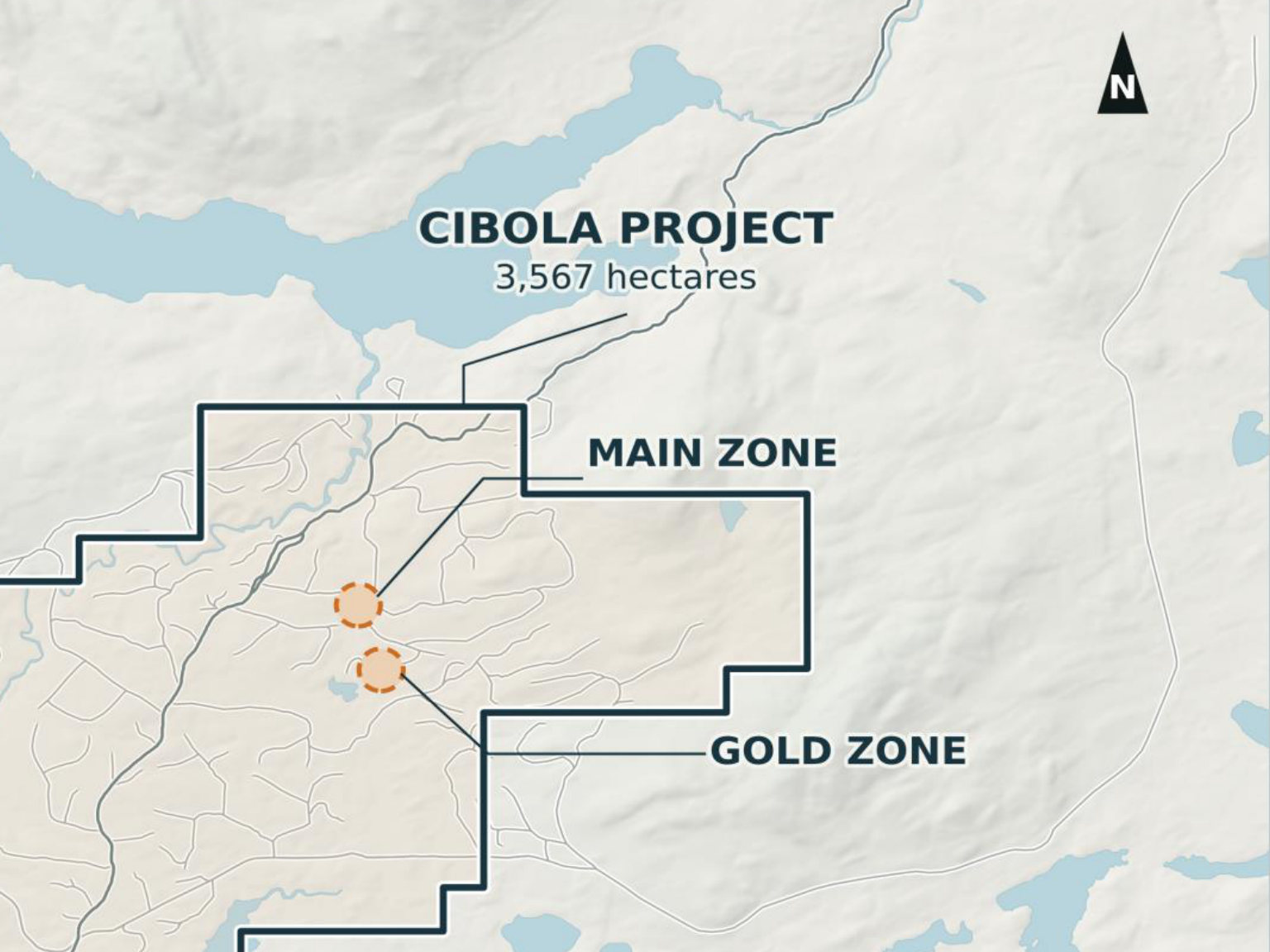 CIBOLA PROPERTY — CENTRAL BRITISH COLUMBIA
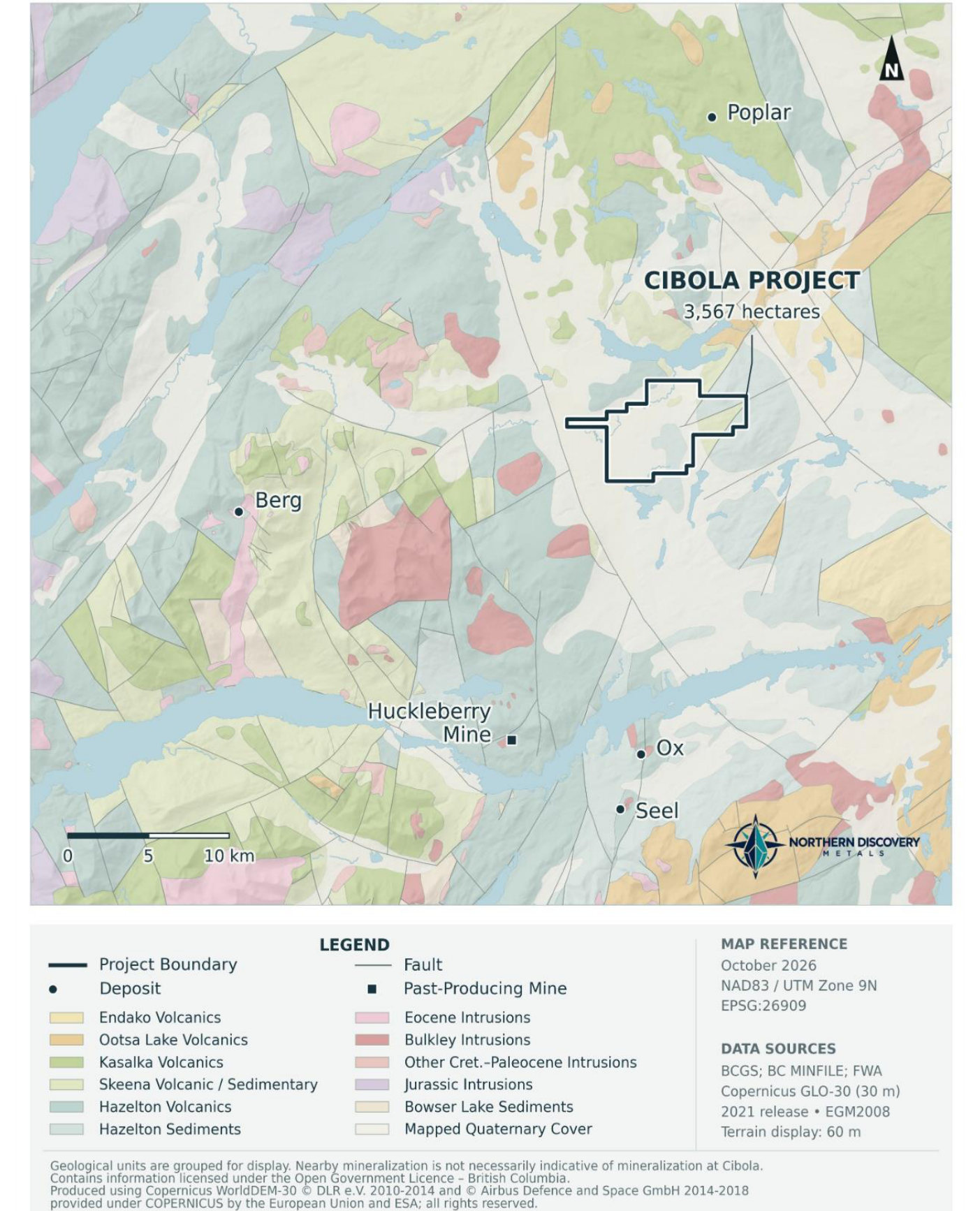
The property is located 90 km south-southwest of Houston in central British Columbia. The haul road from the Huckleberry Mine crosses the property. The property lies 21 km north of the Huckleberry Mine and 28 km east of the advanced Berg deposit.
The area has low relief and extensive glacial-drift cover relative to other regional discoveries, which limits bedrock exposure. Overburden averages approximately 15 m and may contribute to the weak response of conventional soil sampling.
The property is situated in the southern part of the Skeena Arch, an ENE-trending paleo-topographic high in central British Columbia composed of Jurassic and older rocks. The Skeena Arch is flanked to the south by Middle Jurassic to Lower Cretaceous units deposited in the Nechako Basin. Both are known to host economically significant porphyry Cu-Mo and Cu-Mo-Au deposits, commonly associated with the Late Cretaceous Bulkley and Eocene Babine/Nanika intrusions.
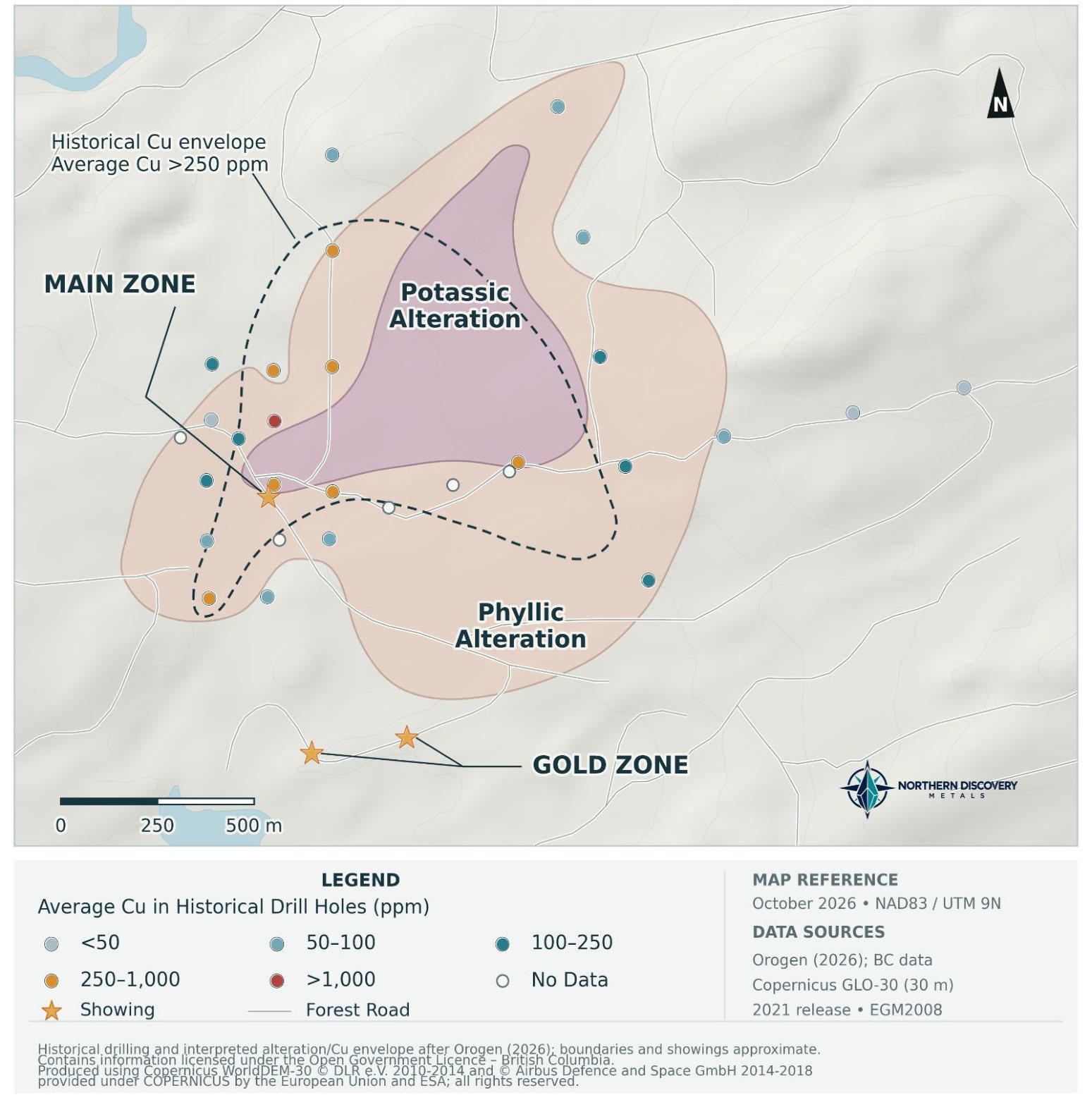
The Main Zone is centred over a small exposure of granodiorite intruding Skeena Group volcanic rocks. The granodiorite and adjacent volcanics are extensively pyritized and altered. Two styles of mineralization are recognized:
Porphyry-style Main Zone
Alteration is interpreted to be concentrically zoned, with a suspected potassic core grading outward into phyllic alteration (1.5 × 1.1 km). The phyllic zone (2–10% pyrite) is coincident with a 2.0 × 1.4 km 40 mV/V chargeability anomaly within a broader 3 × 1.7 km 20 ms chargeability anomaly.
Gold Zone
Volcanic-sediment-hosted showings 700 m south of the Main Zone consist of stockwork veinlets of sphalerite and arsenopyrite with gold.
Cibola lies 21 km north of the Huckleberry Mine and 28 km east of the advanced Berg deposit, and is bounded to the west by Surge Copper's Berg-Ootsa project. Mineralization on adjacent or nearby properties is not necessarily indicative of mineralization at Cibola.
Exploration highlights
West Boundary Target
Historical IP chargeability, magnetic and resistivity high straddling the boundary with Surge Copper's NE Target. Six diamond drill holes were completed here, but results were not filed.
Haul Road Target
Historical chargeability high and a composite Cu-Mo-Bi-Sb and W soil anomaly defined by 2023 sampling, with the highest values near the haul road. The soil anomaly may reflect contamination from mine haulage; however, the IP anomaly remains of interest.
Historical timeline
- 1974–1975
29 percussion holes (1,721 m) drilled on the Main Zone and 6 diamond drill holes along the western claim boundary. Multiple percussion holes were anomalous in copper.
- 2023
Soil sampling defines a composite Cu-Mo-Bi-Sb and W anomaly at the Haul Road Target.
- 2025
Airborne VTEM and magnetic survey indicates at least two high-priority targets beyond the Main Zone.
3D ICP Survey
Complete 3D ICP surveying, with MT coverage to investigate deeper geological structures. Advance drill permitting and First Nations engagement.
Interpretation and Drill Targeting
Integrate survey results with geology, geochemistry and historical drilling. Rank priority targets and finalize the initial drill program.
Initial Diamond Drilling
Test priority targets beneath and beyond the shallow historical drilling and evaluate the depth and extent of the porphyry system.
Results and Follow-up Planning
Report assay results, refine the geological model and design follow-up drilling and fieldwork.
Proposed timing is subject to permitting, funding, field conditions and exploration results.